Save Marlow’s Greenbelt has submitted a formal response to Buckinghamshire Council’s Draft Green Belt Assessment 2026 (linked on the Local Plan website), raising serious concerns about how the Green Belt around Marlow has been assessed.
Our conclusion is simple: the methodology risks turning one of the most important strategic gaps in the area into a patchwork of “grey belt” sites – not through real change on the ground, but through flawed analysis.
The result could be the gradual erosion of the Green Belt through a process we can only describe as “death by a thousand cuts.”
Areas in pink/orange on the map below (a screenshot from Buckinghamshire Council’s Sites Engagement map – if you toggle the right layer, which is off by default) are classified as “potential grey belt”, opening the door to speculative development.
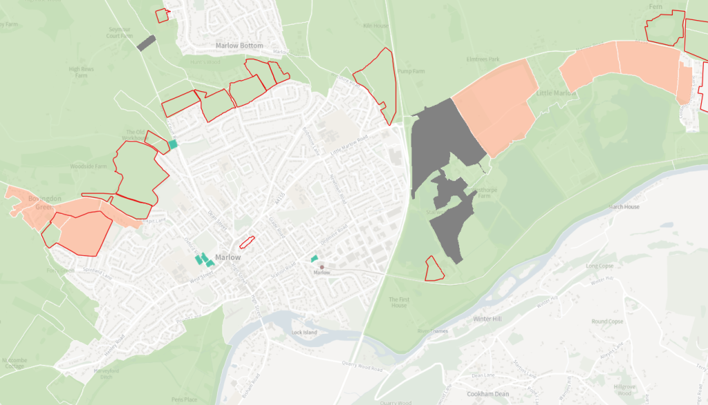
Take for example the countryside between Marlow and Bourne End: it performs a vital role in preventing the two towns from merging. In fact, Buckinghamshire Council itself has previously described this area as “one of the more fragile settlement gaps in the study area” and an “essential gap” maintaining separation between the settlements.
Yet the new 2026 assessment divides this single landscape into eight separate assessment areas. Four of these are now identified as potential grey belt.
Nothing about the land itself has changed since the last assessment in 2016. The landscape, settlement pattern and physical features are all the same. What has changed is the methodology.
In the 2016 Green Belt Assessment this entire segment was essentially assessed as two strategic areas, both of which strongly supported the purpose of preventing towns from merging. The 2026 study instead splits the same land into eight smaller parcels.
This excessive fragmentation hides the strategic role the land plays as a single gap. Instead of evaluating the gap as a whole, each small fragment is assessed in isolation. The same is happening north of Marlow, near Bovingdon Green – and undoubtedly all over the county.
This is not revealing variation in the Green Belt. It is manufacturing it.
Save Marlow’s Greenbelt has asked Buckinghamshire Council to reconsider the assessment before it becomes part of the evidence base for the new Local Plan.
In particular, we have requested that the Council:
- Reassess the Marlow Green Belt segment using a strategic scale appropriate to settlement gaps.
- Restore the ‘Strong’ rating for preventing town coalescence, reflecting the landscape’s true role.
- Properly assess the cumulative impact of releasing multiple parcels/
- Provide clear justification for the significant score changes made since 2016
The Green Belt exists to provide permanent protection against urban sprawl and town coalescence. That protection should not be weakened by flawed methodology.
You can read SMG’s full analysis and response here.